LNU Lightning Complex Fires - September 2nd, 2020
Last updated: September 2nd, 2020 at 11:00am PDT
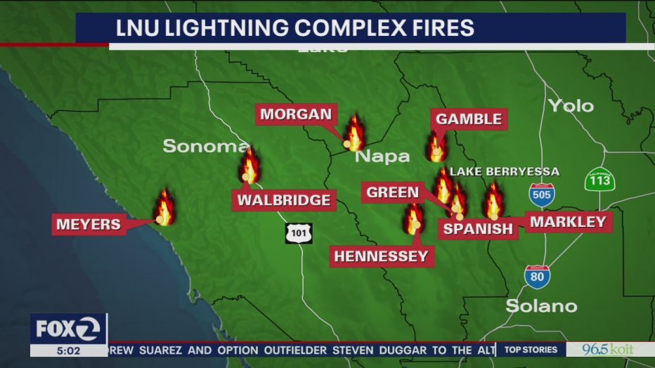
The LNU Lightning Complex Fire is threatening homes near Vacaville and has forced evacuations in Solano, Sonoma, Napa, Lake and Yolo counties.
More fire evacuees have been able to return home as containment grows on a group of wildfires that have chewed through hundreds of thousands of acres in five Northern California counties. As of Wednesday morning, the fires, called the LNU Lightning Complex, had consumed 375,209 acres with 76% containment, Cal Fire reported. The fires have destroyed 1,080 structures and damaged 272 others. The fires continue to threaten 30,500 structures, Cal Fire said.
(KCRA)
Fire updates, evacuations, closures:
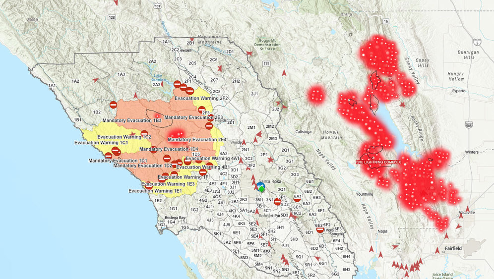
LNU LIGHTNING COMPLEX EVACUATION UPDATE – SONOMA COUNTY
WHAT: EVACUATION WARNING: Potential threat to life and/or property. Those who require additional time to evacuate, and those with pets and livestock should leave now.
WHEN: IMMEDIATELY
WHERE: Affected areas by the Wallbridge Fire are downgrading Evacuation Orders to Evacuation Warnings.
ZONE: All of Zone 2E2 is now under Evacuation Warning
- South of Stewarts Point Skaggs Springs Road
- North and East of Chemise Road
- West of the center of Dry Creek (the actual creek)
ZONE: All of Zone 2E3 is now under Evacuation Warning
- South of Chemise Road
- North of Mill Creek Road
- West of the center of Dry Creek (the actual creek)
- East of Wallace Creek Road (Wallace Creek Road will remain closed)
NOTE: The roadways below will remain closed.
- Wallace Creek Road and Mill Creek Road, west of Wallace Creek Road (including Palmer Creek Road), will remain closed due to hazardous tree removal, powerline repair, roadway repair, and other hazards being mitigated in the area.
ZONE: All of Zone 2E4 is now under Evacuation Warning:
- South of Mill Creek Road
- North of Sweetwater Springs Road
- West of Westside Road
- East of Palmer Creek Road
NOTE: The roadways below will remain closed.
- Wallace Creek Road and Mill Creek Road, west of Wallace Creek Road (including Palmer Creek Road), will remain closed. In addition Sweetwater Springs Road between 17990 and 19500 will reamain closed due to hazardous tree removal, powerline repair, roadway repair, and other hazards being mitigated in the area.
211 Information: You can call 2-1-1 or visit socoemergency.org if you have any questions. Also, take a look at the interactive evacuation map at https://arcg.is/0buuL1 and search by address to see the status of your zone.
NOTES: SAFETY MESSAGE – The public is reminded to stay vigilant on current fire conditions. Please continue to adhere to road closures and any evacuation warnings. A reminder to drive slowly and yield to emergency personnel in the area. If at any time you feel unsafe, please call 911. Residents may experience very smokey conditions as the firefight continues. Smokey conditions can be unhealthful to many people especially children, the elderly, and anyone with respiratory problems. Use caution when returning to the area as conditions to the roadway may have changed due the fire. Power poles, trees, and other structures may have been damaged.
When returning to your home, you may have fire damaged trees on your property. Be aware of falling branches, loose limbs, burned-out stumps, holes, and unstable trees. If there is uncertainty regarding the damaged trees, avoid the area.
Coming home after a wildfire can be difficult. As evacuations are lifted please review the safety steps when returning to your home after a wildfire. For information on returning home visit us at: https://www.readyforwildfire.org/post-wildfire/returning-home/
LNU LIGHTNING COMPLEX INCIDENT UPDATE 9/2/20 7AM
Current Situation: Northeast winds will bring drier air, especially over northern and eastern portions of the complex today. These increasing winds are expected this morning into early afternoon. Crews will continue to work to build containment lines and fire suppression repair teams remain active throughout the area. Many re-populations continue to occur throughout the area.
Napa County and Lake County:
- Hennessey Fire (Merged Fires – Gamble, Green, Aetna, Markley, Spanish, Morgan, Round): Hennessey Ridge Road in Napa County, California: 317,909 acres and 74% contained.
Sonoma County:
- Walbridge Fire (merged with Stewarts): West of Healdsburg: 54,940 acres and 75% contained.
- Meyers Fire: North of Jenner: 2,360 acres and 100% contained.
Evacuation Centers:
- Napa County: Crosswalk Community Church – 2590 First Street Napa, CA 94558
- Lake County: Lake County’s Temporary Evacuation Point (TEP) was demobilized August 28. Those in need of shelter as a result of the fires are now encouraged to call 707-262-4423.
- Yolo / Colusa / Solano County: None
Animal Evacuation Centers:
Napa County
- Napa County Animal Shelter: 942 Hartle Court, Napa, CA 94559
- Valley Brook Equestrian Center: 1132 El Centro Ave. Napa 55 horses
- Napa Valley Horseman’s Association: 1200 Foster Road Napa 61 horses
- Ag 4 Youth 1200 Foster Rd, Napa 62 Ruminants
Yolo County:
- SR-16 westbound @ County Rd 41
- County Rd 41 northbound @ County Rd 41A
Colusa County:
- SR-16 eastbound @ SR-20
- Sand Creek Rd westbound @ Cortina School Rd
Lake/Solano County: None
Sonoma County: None
Evacuations:
EAST ZONE
Napa County:
OES Info:
Evac Info: https://www.countyofnapa.org/CivicAlerts.aspx?AID=182
Napa County Information Line: (707) 253-4540
Napa County Webstie
https://www.countyofnapa.org/2966/19746/LNU-Wildfires
EVACUATION ORDER:
Highway 128 between Monticello Dam and Moskowite Corners (SR128/121 intersection)
- Wragg Canyon
- Markley Cove
- Pleasure Cove
Berryessa-Knoxville Road from Hwy 128 (at Turtle Rock) to Lake County Line
- Community of Berryessa Pines
- Both sides, including resorts and recreational areas of Lake Berryessa, Knoxville
- Aetna Springs Road and James Creek Road
- Pope Canyon Road from Hardin Road to Berryessa Knoxville Road
- Properties on the east side of Highway 29 between Silverado Trail and Lake County line
- Old Lawley Toll Road
- Palisades Road
Evacuation Warning:
- Properties on the east side of Silverado Trail from Rosedale Road to Deer Park Road.
- Howell Mountain Road (AKA Old Howell Mountain Road) from Conn Valley Road up to the intersection of White Cottage Road
- Howell Mountain Road from Deer Park Road to White Cottage Road, including the community of Angwin
- White Cottage Road
- Ink Grade from White Cottage Road to Pope Valley Road
- Chiles Pope Valley Road from 128 to Pope Valley Road, Pope Valley Road to Aetna Springs Road, all roads in between, including Lower Chiles Valley Road
- Pope Canyon Road from Pope Valley Road to Hardin Road, to include Hardin Road and Dollarhide Road
- Butts Canyon Road from Aetna Springs Road to the Napa/Lake County line
- Snell Valley Road, including Berryessa Estates sub-division
- Soda Canyon from Loma Vista to 3700 Soda Canyon Road (Dead End)
- Atlas Peak from 2462 Atlas Peak Road (Bubbling Wells Pet Cemetery) to the dead end.
- Deer Park Road from Silverado Trail to the intersection of White Cottage Road and Howell Mountain Road. This will include the community of Deer Park, Glass Mountain, Crystal Springs, and St. Helena Hospital
- Highway 128 (Capell Valley Road/Sage Canyon Rd) from Chiles Pope Valley Road to Wragg Canyon Road. (Wragg Canyon Road remains closed and under an Evacuation Order)
- Highway 121 (Monticello Road) from Vichy Avenue to Highway 128 (Moskowite Corners)
- Berryessa Knoxville Road from Highway 128 (at Turtle Rock) to Spanish Flat Loop Road, to include Spanish Flat Loop
Lake County:
https://www.facebook.com/lakesheriff/
Evacuation Map: HERE
OES Contact:
707-262-2090
Email Sign-Up:
https://member.everbridge.net/index/892807736729003#/signup
Evacuation Orders:
- East of Middletown Area
- East of Hwy 29
- North of Lake / Napa County line up to the intersection of Hey. 29 and St. Helena Creek (Across from Twin Pine Casino)
- South of Butts Canyon Rd.
Evacuation Warning:
North of Lower Lake Area
- North of Morgan Valley Rd.
- East of Sky High Ridge Rd. extending north to Hwy. 20
- South of Hwy. 20
- West of Lake / Napa / Colusa County lines
South of Lower Lake Area
- South of Morgan Valley Road
- East of Chimney Rock/Canyon Road
- North of Jerusalem Grade Road Extending to Lake/Napa County Line
- West of the Lake/Napa County Line
Middletown Area
- East of Guenoc Winery Road
- North Butts Canyon Road
- South of Grange Road
- South of Butts Canyon Road to Cailayomi Road
- East of St. Helena Creek Road
- North of Hwy. 29
- West of Cailayomi Road Extending to Western Mine Road
Yolo County
Evacuation Order
- Zone 1
- Zone 2
Evacuation Warning
- Zone 3
Colusa County:
Evacuation Order
- Zone C1: All areas and residents West SR-16, South of SR-20, East of the Colusa/Lake County Line.
- Zone C2: All areas and residents North of the Colusa/Yolo County Line, East of SR-16, West of Sand Creek/Green Road, and South of the dead end of Spring Valley Road.
Solano County
Solano County begins phased repopulation process; helping residents safely return home after evacuation. Only residents are permitted to re-enter the area with appropriate Identification.
The following road closures will remain even after phased reopening. Road closure removal will be determined at a future date. Access will remain restricted due to road damage, utility needs and falling trees.
- Gates Canyon Road
- Mix Canyon Road
- Blue Ridge Road
- Cantelow Road from Pleasant’s Valley Road to English Hills Road
- Pleasant’s Valley Road from Shale Peak Lane to Quail Canyon Road
WEST ZONE
Sonoma County:
Residents and visitors can dial 2-1-1
You can also view an interactive evacuation map here
The following areas were downgraded from Evacuation Order to Evacuation Warning:
These areas are being downgraded into an evacuation warning up to ¼ mile of all burn areas. The burn area is still under Evacuation Order, as well as, ordered closed by the Sonoma County Health Officer. Use caution when returning to the area as conditions to the roadway may have changed due the fire and power poles, trees, and other structures may have been damaged.
A portion of zone 1B3 is downgrade from an Evacuation Order to an Evacuation Warning
- North of the community of Cazadero and East Austin Creek (the actual creek)
- East of King Ridge Road and Sewell Road
- ¼ mile West of the burn area
- South of Stewarts Point Skaggs Springs Road NOTE: Stewarts Point Skaggs Springs Road and Chimese Road remain under evacuation order
NOTE: People living on Armstrong Woods Road will still need to check into the traffic post at Armstrong Woods Road at Sweetwater Springs Road and show proof of residency to make access.
The majority of these zones have already been moved into an evacuation warning. This order expands each zone and allows more people the ability to get their properties to inspect for damage, or just get home.
This means you can now return home at your own risk. These areas are still at risk from the fires in the area. We recommend you stay home for the day once you arrive. There’s going to be a lot of traffic in the area so please drive safely; our priority is getting everyone home safely.
All other areas under evacuation order are still closed. We will send an alert for each area as it re-opens. Continue to follow the instructions of first responders in the area and make sure to listen for hi-lo sirens if fire conditions change. Use extreme caution when around any burned areas that may be present. The burn area is under a Public Health Order due to health hazards created by the fire.
The public is reminded to stay vigilant on current fire conditions. Please continue to adhere to road closures and any evacuation warnings. A reminder to drive slowly and yield to emergency personnel in the area.TCP
- Armstrong Woods Road @ Sweetwater Springs Road with residence checks to burn area.
- Sweetwater Springs Road, no residents passed 17990
- Armstrong Woods Road, no residents passed 16881
- Sweetwater Springs Road @ Westside Road – no traffic on Sweetwater Springs Road
- Mill Creek Road @ Wallace Creek Road – No traffic into the burn area
- Chemise Road @ Burn Area – no traffic into the burn area
- Jameson Road @ Burn Area
Road Closures
EAST ZONE
Napa County
- SR-128 eastbound at Chiles Pope Valley Road
- SR-128 westbound at Pleasants Valley Road
- Aetna Springs Rd @ Butts Canyon Rd
- James Creek Rd @ Butts Canyon Rd
- Pope Canyon Rd eastbound @ Hardin Rd
- Berryessa Knoxville Rd northbound @ Spanish Flat Loop Rd, to Lake County
Lake County:
Middletown:
- Butts Canyon Road eastbound at Oat Hill Road southbound
Yolo County:
- SR-16 westbound at County Road 41
- County Road 41 northbound at County Road 41A
- SR-128 westbound, east of Pleasants Valley Rd.
Colusa County:
- SR-16 south/eastbound at SR-20
- Sand Creek Road westbound at Cortina School Road
WEST ZONE
Sonoma County:
- Peck Road at Burn Area
- Chemise Road at Burn Area
- Brack Road at Burn Area
- Jameson Road at Burn area
- Mountain View Ranch Road at Burn Area
- Koch Road at Burn Area
- Wine Creek Road at Burn Area
- Wallace Creek Road
- Palmer Creek Road

News Coverage
- LNU Complex Fire (The Mercury)
- LNU complex fire surpasses SCU fire as 2nd largest in CA history (ABC 7 News)
- Fire Updates (San Francisco Chronicle)
- Bay Area fires: Complete list of evacuation orders, school closures, and more (KRON4)
- Emergency centers information
- SF Gate