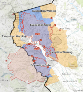
Glass IncidentLast updated: Friday, October 9th at 9:15am PDT
Napa & Sonoma Counties, CA: Glass Incident
Crews experienced minimal fire behavior on the Glass Fire throughout the night. These conditions consisted of creeping and smoldering fire behavior within the current perimeter (CAL FIRE).
Areas of Northern Napa County bordered on the West by Hwy 29 at Livermore Rd, the North by the Lake County line, the East by Aetna Mine Rd, and existing evacuation orders to the South
Areas of northern Napa County bordered on the west by Hwy 29 at Robert Louis Stevenson trailhead, the north by Livermore Rd and east by Aetna Mine Rd
All addresses on Old Lawley Toll Rd
The areas between Old Lawley Toll Rd and Pope Valley Rd from Ink Grade Rd to Aetna Springs Rd
All recreation areas in or near the RLS park including but not limited to Table Rock Trail, Palisades Trail, and Oat Hill Mine are closed
East of Howell Mountain Rd from Crestmond Dr to Cold Springs Rd including Las Posadas Rd and Linda Falls Terrace
Dutch Henry Canyon Rd
Glass Mountain Rd
Meadowood Lane including Meadowood Resort
The community of Deer Park
St Helena Hospital
Mund Rd
Sanitarium Rd
All of Lommel Rd
All of Crystal Springs Rd and North Fork Crystal Springs
Deer Park Rd from Silverado Trail to Howell Mountain Rd
Area north of Boothe State Park to Diamond Mountain Rd