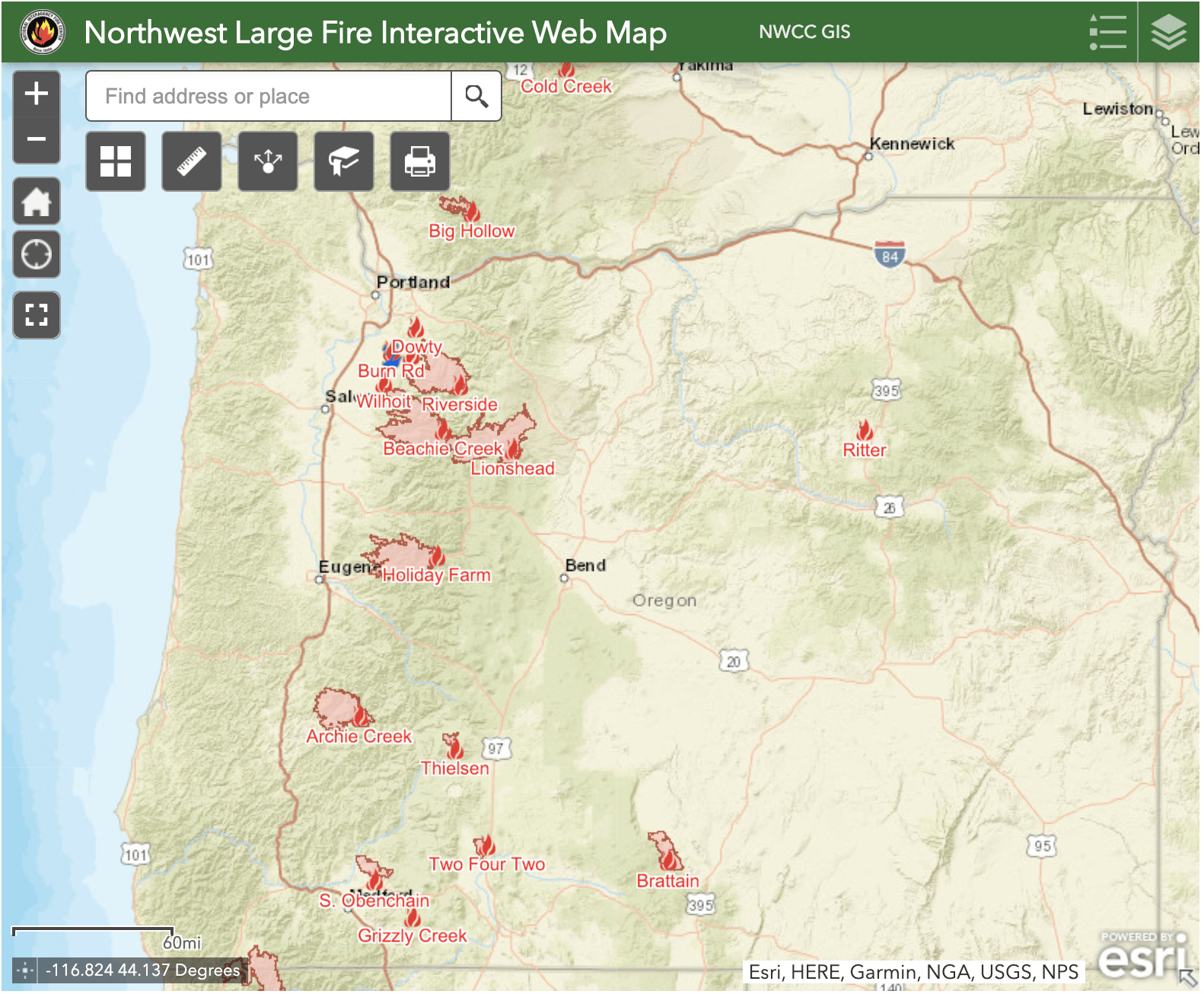
Marion County
Level 3 – Evacuation order:
- Detroit
- Idahna
- Breitenbush
- Hwy 22 @ N Fork Rd east to Mile Post 29, including N Fork Rd, Pioneer Rd, and other roadways in this corridor
Level 2 – Evacuation Warning
- Lyons
- Mehama
- Mill City
- Gates
- Fernridge Rd west of Shellburg Creek Rd to Basil Hill
- Crooked Finger Rd and Moss Ln
- Wagner Rd
- Wagner Ln
- Teeters Rd
- Gopher Ln
- Jennie Rd south of Hwy 22
Linn County
Level 3 – Evacuation Order
- The area east of the end of Gates Bridge East to the Hwy 22 Junction within Linn County
Level 2 – Evacuation Warning
- The City of Lyons, including 16th St behind Freres, and Clipfell Ln, and all areas between the railroad tracks that intersect with Hwy 226 and north to the Linn/Marion County line, east to Cedar Mill Rd, south to Thomas Creek Dr
- The Cities of Mill City and Gates including Cedar Mill Rd on Lyons-Mill City Dr, to the end of Gates Bridge East, and all side roads
Clackamas County
Level 3 – Evacuation Order
- Dodge
- Bedford Point
- La Dee Flat
Level 2 – Evacuation Warning
- Parts of Elwood
- Parts of Faraday
Lincoln County
Level 3 – Evacuation Order
- All of N Panther Creek Rd, N Deer Valley Rd, and N Yodel Rd, and all side roads
- N Corkhill Rd, N Durette Rd, and addresses on N North Bank Rd between N Deer Valley and N Panther Creek
Level 2 – Evacuation Warning
- N North Bank Rd from Hwy 18 to North Panther Creek
- The West portion of N North Bank Rd from N Old Scenic Hwy 101 to 0.5 mile marker
- Hwy 18 residential addresses between N Old Scenic Hwy 101 and milepost 5
Lane County
Level 2 – Evacuation Warning
- Hwy 126 between Camp Creek Rd and McKenzie Ranger Station, including connecting roads
- Deerhorn Rd and connecting roads from the west entrance at Hwy 126 to the last residential property
Jackson County
Level 3 – Evacuation Order
- Areas inside the immediate burn area.
Level 2 – Evacuation Warning
- Portions of Talent west of Talent Ave
- San George Estates
- All properties accessing Brophy, Ball, Reese Creek, and Worthington Roads
- All properties on Crowfoot Rd, 1 mile north of Butte Falls Hwy to OR-62
- Areas south of OR-140 and north of Brownsboro
- Butte Falls Hwy from OR-62 to Reese Creek Rd and all of Hwy 62
- Nearly all of the City of Shady Cove and Trail
Douglas County
Level 3 – Evacuation Order
- Dry Creek (Happy Creek Ln, Felix Flat, Elk Ridge, Illahee)
- Steamboat Creek to the Green Bridge in Glide
- Bar L Ranch Rd
- Diamond Lake
Level 2 – Evacuation Warning
- Parts of Steamboat
- Parts of Idleyld Park
- Upper Terrace Dr
- Terrace